Donald R. McClarey
Cradle Catholic. Active in the pro-life movement since 1973. Father of three, one in Heaven, and happily married for 43 years. Small town lawyer and amateur historian. Former president of the board of directors of the local crisis pregnancy center for a decade.
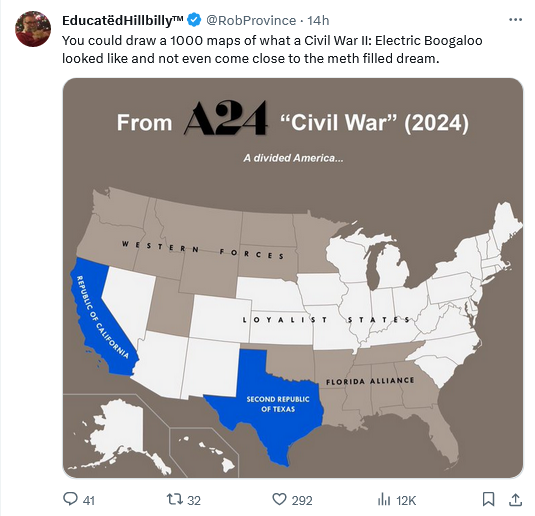



Perhaps he is living the Leftist’s dream of a Blue Texas. It could happen with unrestricted, illegal immigration
“It could happen with unrestricted, illegal immigration.”
True enough. Fortunately, the Great State of Texas has just enacted a law permitting local and state law enforcement officers to arrest illegal immigrants. Democrats are already filing their lawsuits claiming the states have no such authority. The battle lines between law-abiding Americans and most Democrats with respect to immigration are being drawn in big, bold lines. This will be a legal war for the ages, and one hopes that it is the only war the left’s infatuation with “migrants” will cause.
This map puts Missouri and Illinois in the same group, most likely because of their location to one another. Illinois is very blue, (at least politically because of Chicago) and Missouri is very red, despite the governance of St. Louis and KC. My county, Jefferson, is entirely Republican governed. A real Civil War would not divide the states so conveniently.
Texas needs to make immigration from California illegal.
“This map puts Missouri and Illinois in the same group”
Along with Indiana, Iowa and Kentucky, which makes no sense. Also, at least the southern half, and possibly the southern 2/3, of Illinois would NOT side with Chicago in the event of civil war.
I’d think a civil war scenario would have two sides. A dissolution could easily have five regional countries. Just guessing here, but this map could kinda work if California stayed loyal and TX – FL – West broke away together as allies or possibly one country.
I wouldn’t be sure which states would opt to split on a yea-or-nay vote. Looking at our last go-around, Maryland, Delaware, and Tennessee weren’t certain, and the idea that any Virginia territory would be part of the North would have been a long-shot bet.
The thing that jumps out at me is that it doesn’t even work if you figure “oh, use the existing state lines to get the idea across of what happens because geography.”
As to Virginia Pink, the idea that West Virginia was intensely pro-Union would have taken no one by surprise in Virginia. Tennessee was pro-Secessionist except for Eastern Tennessee, which was pro-Union and would be a Republican stronghold in the future Democrat solid South. As for Maryland, Baltimore was pro-Secession and kept in the Union only through military occupation, Delaware had few slaves and no serious Secession movement existed there.
I can’t imagine currently California and Texas being on the same side in a civil war. The map is the geographic equivalent of word salad.
I had read the map as presenting a breakaway California, a breakaway Texas, and a US with tenuous loyalty in the South and West. I wouldn’t assume cooperation between Cali and Texas any more than between post-Soviet Kazakhstan and Estonia. I guess that doesn’t explain why they’re both blue though.
“I wouldn’t assume cooperation between Cali and Texas”
The trailer of the film does, referring to them as the Western Forces.
The intended audience couldn’t find their home state if they had six eyes and an engraved invitation.